Erewash Canal
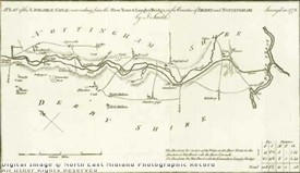
Plan of the Erewash Canal, 1776, by J. Smith
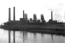
The Stanton Ironworks beside the Erewash Canal, 1931
For the greater part of its route, the canal forms the western border between Nottinghamshire and Derbyshire.
It was begun in 1777, an act having been obtained by the extensive coal-owners in the south-western part of Nottinghamshire, to make a navigable waterway from Langley Bridge to the Trent opposite the Soar.
Overseeing construction was the noted canal engineer William Jessop, who lived in Nottinghamshire at the time.
For more information on William Jessop click HERE
The canal commenced at the Trent near Sawley, and ran parallel with the River Erewash.
After passing collieries around Langley and Heanor, it terminated at the Cromford Canal near Langley Bridge.
Describing the canal in the early 19th Century, the Nottingham & Derby railway Companion of 1839 notes that the canal ran in an ostensibly northern course for 11 1/4 miles, falling 108 feet 8 inches along its course by means of fourteen locks.
Its chief trade at that time was recorded as coal, limestone, iron, lead, millstones, grindstones, marble, freestone, chert, corn, malt and deals.