FARI Archaeology
Summer 2005
Richard Tyndall
Roman Wall
Richard Tyndall

Archaeology Research and Investigations in the Newark Area
By Anne Coyne
Site Location Featured on Time Team's Big Roman Dig
go to www.fari.org
Farndon Sandhill Road site. Located in a private garden on Sandhill Road at Farndon near Newark in Notts.
Grid Ref SK 772523
Nature of fieldwork
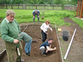
The fieldwork consisted of a series of excavations investigating Roman-British rubbish pits cut into and making use of channels in a, now buried, river bank. In addition to the six trenches excavated, a series of geophysical surveys of the adjacent meadows were undertaken.
The first excavation was a clean up of sections in a garden pond being dug by the landowner. This was followed by five further excavations over 2 years looking at the nature and extent of both the Romano-British river bank and the waste whish had been deposited in the channels and pits.
Two seasons of excavation were undertaken. The initial investigation and enlargement of the garden pond in April of 2005 was followed. By three further trenches in July of that same year. FARI Archaeology then returned to the site in 2006 to open two further trenches. All work on the site is now completed.
The field work was instigated to following the discovery of large quantities of Romano British pottery from a garden pond being dug at the site. Investigation in the records of the local museum found that another collection of pottery had been recovered by a previous landowner in the 1950s from a series of unrecorded holes across the garden.
The site is located on a sand and gravel ridge which runs SW-NE above the flood plain of the river Trent. The edge of the ridge is today located at the foot of the garden closest to the river which lies some 100 yards to the north east.
The Roman fort of Ad Pontem is located some 2000m south west of the site and a number of other locations in the village along the ridge have yielded pottery of a Romano-British date.
The church of St Peters dates to the late Saxon period but is the only building older than 18th century left standing in the village.
The site itself is a private garden attached on a housing estate built in the 1950s. Prior to this is was open meadow land.
Results of fieldwork
A series of excavations delineated the extent of the sand ridge and the approximate edge of the river bank in the Romano-British period. They revealed a large natural stream cut through the sand bank and there was some slight evidence of this having been widened or deepened during the Romano-British period.
- The Romano British deposits consisted of dark, organic-rich silts and clays containing burnt material, ash, horse and cattle bones, numerous sherds of pottery and rare metallic items including hobnails. There were also occasional worked stones and a number of tegulae. The pottery was analysed by Ruth Leary who found that apart from a small amount of late Iron Age, it consisted almost entirely of mid to late 4th century material, overwhelmingly local fabrics from the Swanpool kiln at Lincoln. There were also at least two Oxford red colour coated bowls and occasional sherds of Nene Valley ware. A single coin dating to the reign of Valentinian (364-375AD) was also found.
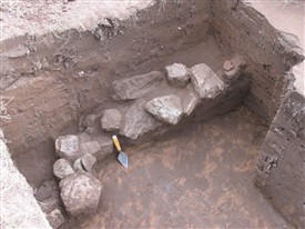
- The Romano British material overflowed the stream channel and formed a layer of between 80 and 150mm deep across the surface of the sand bank. Within this horizon a compact clay floor measuring 2m by 1.5m was uncovered and, in a separate context but still within the Romano British horizon, a short section of rough walling, perhaps a retaining wall running sub parallel to the edge of the bank. This wall is both within and overlain by the midden material and whatever structure it originally represented apparently ceased to be used before the end of the Romano-British period.
- Overlying the Romano British material across the whole site was a 150mm to 300mm thickness of wind blown sand. A few sherds of 13th – 14th century green glazed pottery were found very close to the top of this context but it was otherwise barren of finds.
- The site appears to consist of a Romano British midden utilising a pre-existing stream channel cutting a sand bank at the edge of the River Trent. There is some evidence of digging within the stream channel but the purpose of this is not clear. Pottery finds would indicate that the settlement providing the material for the waste pit was not of a particularly high status. The presence of the clay floor and the short section of wall both within the overflow of the Romano British material indicate some form of structure in the upper part of the midden although there is insufficient evidence to indicate what form this might have taken.
- It is apparent that the site ceased to be used by the end of the Romano-British period and the wind blown sand horizon which overlies the occupation layers represents an extended period of abandonment probably until at least the 13th or 14th centuries.