The Chesterfield Canal in Notts
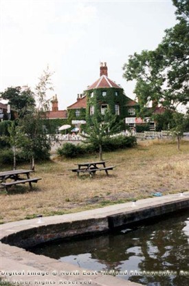
The Griff Inn, Eel Pool Road at Drakeholes in the 1990s. This popular pub lies next to the Chesterfield Canal. The pub was originally built as the White Swan in the late 18th century by Squire Jonathon Acklom of nearby Wiseton hall. It overlooks a wharf on the Chesterfield Canal and is adjacent to Drakeholes Tunnel. The name was changed by licensee J Griffiths in recent years.
Ian Brown LRPS & www.picturethepast.org.uk
The first public meeting to discuss the building of the canal was held at Worksop's Red Lion public house on 24 August 1769.
It was considered that coal from the north Notts coalfield would be the most important cargo, as with cheaper transport by water, the canal company aimed to undersell the rival south Yorkshire coalfields
Consulting engineer was James Brindley who confirmed that a canal from Chesterfield to the River Trent was technically viable.
. Brindley's assistant, John Varley, was made Clerk of the Works, Resident Engineer. Work started in October 1771 at Norwood Tunnel, the digging of which was to be a four-year task. Meanwhile the canal was built eastwards towards Worksop and Retford. In May 1775 it was agreed that although the canal was to be narrow from Chesterfield to Retford it should, nevertheless, be built larger between Retford and the Trent so that it could carry wide-beam river-boats. The entire canal was officially opened on 4 June 1777
The following is an account of the Chesterfield Canal extracted from John Piercy's 'History of Retford' (1828):
'This highly useful undertaking, which forms a prominent feature in the history of this place, was begun in the year 1771, and first opened throughout the whole line on the 12th of September, 1777 . Previous to this, the northern districts of this county were greatly deficient in that mode of commercial intercourse, and the trade much clogged and impeded from the high rate of land carriage. In the year 1770, the scheme appeared so manifestly advantageous, and its result so certain, that an Act of Parliament was obtained, constituting 175 individuals, as trustees of the body corporate, under the title of 'The Company of the Proprietors of the Canal Navigation, from Chesterfield to the River Trent;' to have perpetual succession, and a common seal. The ground space on the line specified in the Act, including the canal, towing paths, ditches, drains, fences, etc was not allowed to exceed twenty-six yards in breadth, except in such places where the canal shall be raised higher, or cut more than five feet deeper than the present surface.' By another clause it is enacted that no person or persons whatever, 'shall cause to be erected or built any wharf or warehouse, or other building, upon or within one hundred yards of either side of the said cut or canal, in any part of a certain common called East Retford Common, between a point of the said canal, beginning ten yards west of the south-east corner of a certain ground or garden in East Retford aforesaid, belonging to the heirs of John White, Esq. deceased, and now or late in the occupation of William Wilson, adjoining the said common, and a certain place called the Spaw, situate upon the said common.'
This canal enters the county of Nottingham near Shireoaks, and after passing Worksop, Osberton, and Babworth, in a circuitous course, comes into this parish in the south-west, and just skirting the town on the south, it suddenly changes its course towards the north, and after passing through eleven or twelve parishes, falls into the Trent at Stockwith. The distance from Chesterfield to Stockwith, taking the line of the canal, is about forty-six miles, and from Norwood its regular fall is three hundred and thirty-five feet. The quantity of land taken up in this parish by the excavations, banks, etc was the property of those free-holders of Retford, who possess the right of pasturage upon the cars and commons, amounted in the aggregate to six acres and fourteen perches; the canal company's allowance for the same, was £47. 7s. 6d. which sum, on the 5th of November, 1778 , was agreed to be expended in draining the cars and commons agreeably to Mr. Varley's plan.
From Retford to Stockwith, the canal is on a more extended scale, and the locks double the width they are from Retford to Chesterfield . Thus we find from a memorandum in the books of the Corporation of this place, dated the 13th of September, 1775, that it was resolved by the bailiffs and aldermen, that £600 should be borrowed by the Corporation, and the same sum paid to the Chesterfield Canal Company for making the canal from East Retford common to Stockwith upon, a larger plan, whereby vessels of greater burden can navigate the said canal, than otherwise would have been the case. To enumerate the advantages which have already resulted to the town and neighbourhood from this superior method of communication, would be quite superfluous; suffice it to say, they have been generally felt by all classes; and, although the principal aim of the original projectors was the export of agricultural produce, and the importation of coals from the adjacent mines in the county of Derby, together with that of lime, timber, and other heavy articles; yet, the facility of intercourse which it ensures with our home markets, and the communication it offers with the port of Hull and consequently with every part of the globe, renders it the medium of imparting the necessaries of life, at a rate more moderate and easy than any other which has yet been devised. The canal company have a commodious warehouse for the reception of corn and other commodities, at which, an attendance is given by Mr William Welsh, their sub-agent and warehouseman. The canal passes over the river Idle on the south-west of the town.'